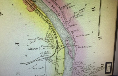
An 1877 map of the Ohio River Valley identifies “Mingo Bottom” near the location that is now Follansbee. Also, the map identifies landowner and various creeks including McMahan Run, Mahan Run, and Cross Creek. A school appears to be near what is today called Alleghany creek. The map also identifies a cave where Indian skeletons were found as well as a ferry landing located at the mouth of McMahan Run, just north of present day Follansbee. The Pittsburgh-Wheeling-Kentucky Railroad is shown running along the east side of the bottoms of “Mingo Bottom.” Mingo Island is shown in the Ohio River near the West Virginia shore just north of Cross Creek near present day Follansbee. To see Mingo Island on detailed map, go to the link below.

- Rumsey, D. (2017). Upper Ohio river and valley: Part V. Retrieved from https://www.davidrumsey.com/luna/servlet/detail/RUMSEY~8~1~3505~380022:Upper-Ohio-River-and-Valley-part-V