All posts by follansbee

1799- Founding of Tent United Church

Historians including H.J. Newton have documented the earliest years of the Tent Church. The beginnings of the church occurred prior to 1800 when a missionary station and preaching took place at the homestead of Mr. Wiggins, along cross creek, Brooke County, VA.  As the ministry grew and organized, the church was initially called Cross Creek Church, after its first ministry at the Wiggins farm along the creek.

About 1799 the church was formally established by the United Presbyterians about 3 miles north of the Wiggins farm near the road from Steubenville to Washington, PA.  “The church was probably organized by Rev. John Anderson, founder of the Pittsburgh Xenia Theological Seminary.” The deed for 2 acres of property for the church and cemetery was dated June 27, 1803.

Prior to the erection of the first church building, services were held outside at a crude log structure closed on three sides, and opened in front.  A stand or pulpit for the minister was placed facing the audience.  Seats for the congregation were arranged in the clearing among the forest trees. As the congregation grew in size, it was a common practice to use tents of canvas as shelter in case of inclement weather.  Folks referred to this practice as a “Tent Church” and that designation is what the church is known as today.  

The first church building was constructed of rough hewn logs.  The story of the log church has passed down over generations, yet the exact construction date is unknown.  A glimpse into the pioneer customs of the men who gathered together and helped built the first Tent Church follows:  “Whiskey was always plentifully supplied at all public gatherings, such as logrolling and raisings.  At the raising of the log building for this church the supply was exhausted before the house was up and a boy was immediately dispatched to the nearest still house for a new supply.”

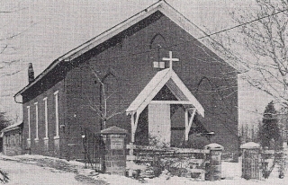
In 1938 the Follansbee Review published the account of an annual homecoming celebration at Tent Church. Memories of the old church were recalled by many who were present for the homecoming. During the morning session, a report of the church records was presented by F. Herbert Wells, a prominent local citizen who was the main speaker.  He noted that the records were incomplete, with spans of time not chronicled.  Wells recognized the efforts of Mr. Love and Mr. Gillespie who erected the current church building in 1873, and Mr. Halstead and son, Darwin Halstead, who made the original seats and pulpit.

The Tent Schoolhouse stood next to the Church, and served the children of local pioneer families until it was consolidated with the Colliers School in the early 1920s.

The Tent Farm Women’s Club was founded in 1925 to represent the local families who identified with the Tent Church.  One of their objectives was to support in every way possible their Church.  The first president was Mrs. Wilbur Freshwater.

The Tent Church cemetery, beside the church, was established in the early 1800s. ”Buried there are a number of historic families of the area including the:

MORES, PUGHS, POOLES, RAYLANDS, STRAINS, WILLIAMSONS, ARCHERS, COXES, BROWNS, CRALLS, CREWELLS, DIVITTS, FRESHWATERS, FERGUSONS, HINDMANS, HUNTERS, HALLS, HAYS, HANLINS, KLENIS, MURCHLANDS, McCARROLLS, McDONALDS, & MILLERS.
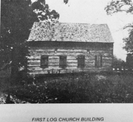
log Tent Church IMG_0990 IMG_0991 IMG_0993


* “History of the Pan-Handle: Being Historical Collections….” J.H. Newton, G.G. Nichols, & A.G. Sprankle (1879), Google Books Online, pp. 322-323.

* Follansbee Review, “Annual Homecoming Celebrated.” Sep.  8, 1938. p.1.

* “From History – by June Grossman & Catherine Slasor,” Brooke Co. Genealogy Society, Online,  (a brief history of Tent Church, posted 2016.)

* “Early Cemeteries of Brooke County,” Brooke Co. Genealogy Society, Online.

*  “The Tent Church Cemetery: The Cross Creek Cemetery,” Online, Brooke Co.  Genealogy Society, posted 2016.

* See Nov. 16, 1955 – 30th Anniversary of Tent Farm Women’s Club on Follansbee Timeline.


1793 – Olde St. John’s Episcopal Church

Built in 1793, the first log church was destroyed by Indians. The following year, the original church was replaced by a frame dwelling one mile farther east on the north side of the present church yard. In 1800 the church had 43 subscribers.

An 1849 building serves the congregation today. Olde St. John’s is the first Episcopal Church established West of the Alleghany Mountains. Reverend Joseph Doddridge established the congregation. His missionary work extended over thirty years throughout the northern panhandle and as far West as Chillicothe, Ohio.  Doddridge also established a church in Wellsburg and a congregation at West Liberty. His education included studies at Jefferson Academy, now part of Washington and Jefferson college. In 1800, Doddridge was living in Wellsburg and died in 1826. “In 1929 a stone tablet, inscribed to the memory of Dr. Doddridge, was incased into the western wall of the church, a tribute to his noble and untiring efforts.”  Olde St. John’s is located on the intersection of Eldersville and St. John’s roads, which were once Indian paths. The graveyard adjacent to the church contains graves dating back to the 1700s.

st_johns Old St. John Church.


IMG_2754


IMG_2751


IMG_2732


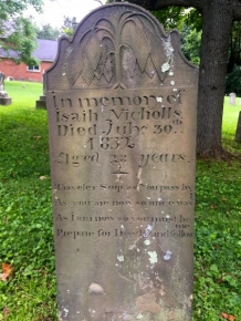
The grave stones of St. John’s Church represent many Pioneer families. 


  • Follansbee Review, “Annual Services at St. John’s Church,” May 28, 1931, front page


1792 – Last Victim Killed By Indians In Brooke County

John Decker, son of John Decker of Decker’s Fort, remained behind when his father and family left Mingo Bottoms in 1784 and gradually resettled in Indiana. 

The young Decker established his own homestead near West Liberty. While riding to Holliday’s Cove (Weirton) along a ridge on the east side of Scott’s run he discovered Indians in pursuit. “They fired and a ball broke his horse’s leg.  He then attempted to escape on foot, but was overtaken and killed.” Thomas Wiggins, who lived near, alarmed by the firing, seized his rifle and hastened to the area where the shots occurred and found the body of Decker.

  • Virgil A. Lewis, “History of West Virginia in Two Parts,” (Hubbard Brothers, 1889), p. 581.

May 1782 – Rendezvous At Decker’s Fort Against Ohio Indians

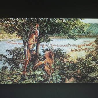
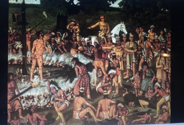
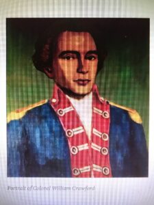
As the Revolutionary War raged on, a force of 480 volunteers assembled on John Decker’s former land for a powerful expedition against Indian villages on the Sandusky River in Ohio. The rendezvous site was at Decker’s Fort, on the Ohio River across from present day Mingo Junction. Decker’s Fort was chosen because it was an easy crossing place. The river was shallow enough to be forded without having to swim during the dry summer mouths. The actual crossing was about a mile above Cross Creek on the Virginia shore near Mingo Island. The expedition crossed the river and set up a camp on the bottom land of 250 acres formerly occupied by a Mingo Village which was destroyed in 1772. The expedition was led by William Crawford, a prominent Revolutionary solider who accompanied George Washington down the Ohio River in 1770.  The expedition went deep into Indian territory but the Indians and British defeated Crawford’s force. Crawford was captured, tortured and burned at the stake.

5


1782 Crawford


Crawford burned at the stake


Colonel William Crawford

  • Allan W. Eckert, “The Dark and Bloody River: Chronicles of the Ohio River Valley,” (New York: Bantam Books, 1996, pp 329-330.
  • G.W. Butterfield, “Historical Account of the Expedition Against Sandusky Under
  • Col. William Crawford in 1782,” (Robert Clarke & Co., 1873).

1780-Alexander Wells Claims Ownership Of “Old Mingo Bottom”

Wilderness land speculation often resulted in multiple and overlapping land claims that were frequently reconciled via wheeling and dealing.  According to a 1906 History of Follansbee, Wells took a suit against the heirs of John Decker and won ownership of  some of the land comprising present day Follansbee.  Prior to the suit against Decker, Wells received a patent for 200 acres granted by Thomas Jefferson, Governor of the Commonwealth of Virginia.   The patent was based on Wells’ rights as a former soldier whose service in the French & Indian war awarded him land grants in the frontier territory.  It is not certain when Wells actually took sole possession of the property from John Decker.

Wells had extensive property and business interest in Washington County, Pa., and along Cross Creek, where he erected a gristmill and distillery.   For more information on Alexander Wells, see “The Little Wells Family..” below.  In 1799, Wells’ land became the property of his son, Henry Wells, who remained owner until his death in 1815. Henry Wells built a one-room addition to the old log house constructed originally on the land by Isaac Cox in 1772.

1775-1783-Revolutionary War Against England

The next historic stage that influenced the area now known as Follansbee involved the war for independence against England. During the bloody war, Indian raids intensified as Mingo and Shawnee allied themselves with the British. The British supplied them with muskets and gunpowder as they attacked local outposts.  A Fort at Holliday Cove (Weirton) housed militia that protected the present day area of Follansbee.  In 1777, militiamen from Fort Holliday helped to rescue inhabitants at Fort Henry in Wheeling from a siege of 350 Wyandot, Shawnee, and Mingo armed by the British. In 1782, Fort Decker (Follansbee) was the site of a rendezvous of militiamen, mostly from Pennsylvania, for an attack against Ohio Indians. (See 1782 on timeline).

Militiaman 1775


British troops fire on Militiamen.

1775-Jacob Walker & Walker Road

Born in Ireland in 1755, Jacob Walker came to America as a stowaway.  Upon arrival his uncle agreed to pay his fare so long as Jacob worked for him six months.   In 1774, he started on foot from Baltimore coming to the Ohio Valley by way of Fort Pitt.  Shortly afterwards he began working for Harmon Greathouse clearing land and planting corn.    Walker then bought 400 acres from Greathouse and returned to Baltimore to marry Margaret Guthrie.   He purchased a horse and brought his bride back arriving at a cabin near Decker’s Fort (Follansbee).   According to folklore, he told Margaret this was her new home.  “She sat down and had herself a good cry.”

Jacob Walker was one the early settlers identified with the construction of Fort Decker, located in the vicinity that is now Follansbee. (See Decker Fort on Timeline) As the Revolutionary War raged, they stayed for seven summers with the small community at Decker’s Fort.  They spent the winters on their farm located in what is now the Parkview addition of Follansbee.  The Walker Road, named after the Walker family, became one of the earliest routes into what is now Follansbee. The road descended the hill near the top of today’s Banfield avenue.

1774 – Indians Fire On Settlers From “Mingo Island”

Mingo Island no longer exists.  But, in 1774 it was situated close to the Virginia shore near today’s Follansbee.  The island of about 20 acres contained large maple trees on high ground.  Most of the timber was washed away by a great flood in 1832 that reduced the island to half its earlier size. Afterward, the island was covered with scrap willow and slowly eroded away finally disappearing around 1918.  Indians used Mingo Island to fire upon settlers along the Virginia shore.  According to local folk lore, a large rock, known as the “Indian rock” on the hill above Highland Avenue (later known as Banfi Hill) at the corner of State Street, was once used by settlers to shoot Indians across the river and on Mingo Island.

IMG_0544
Mingo Island before Follansbee was Chartered in 1906


  • Mario Cipriani, Oral Interview, Follansbee, WV, January 2011.

1774 – John Decker’s Fort

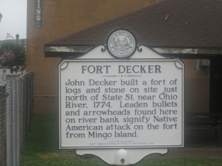
Isaac Cox transferred all his land including the log house over to John Decker, a rich landowner.  Even though the French & Indian War had ended, Indian attacks along the Ohio River continued through the 1790s.   The fort was the site of many conflicts as Indians fired upon the settlers from nearby Mingo Island. To protect his family, Decker built a fort or blockhouse of logs and stones.  Decker’s Fort was located on the ground later used by the railroad between Broad Street and the Ohio river. Decker’s 343 acres comprised land from the Wabash Bridge, including property later owned by W.B. Mahan in what is now Follansbee.

Another event connected to Decker’s Fort occurred in October 1776. A volunteer force under the command of Isaac Cox gathered at Hollidays Cove (Weirton) to provide defense of settlers along the Ohio River, including the vicinity of Decker’s Fort. This event represents a rare snapshot of the Decker’s Fort area, which was described as a small settlement protected by the volunteers while settlers gathered their corn.

picture-2-deckers_fort


John Decker – road marker.

1772 – Isaac Cox Settles At “Old Mingo Bottom”

Following the treaty of 1768 and Washington’s journey down the Ohio River in 1770, English settlers were again moving into the valley. Among these first brave pioneers who  settled in Old Mingo Bottom (Follansbee) was Isaac Cox and companions.  They erected a log house, a symbol of the rugged ancestors of Follansbee.  The log cabin survived in various conditions for nearly a hundred years as the property passed to other owners until the Mahan family sold the land to the Follansbee brothers.  (See 1902 on Timeline)